


.bmp)


.bmp)
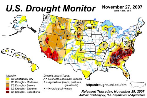 November 30, 2007: From the deserts of the American southwest to the pine forests of the Deep South, drought-weary residents have one thing on their minds: "I wish it would rain!"
Technically, what they should be wishing for is "more streamflow," says Dr. Ashutosh Limaye, a hydrologist at the National Space Science and Technology Center (NSSTC) in Huntsville, Alabama.Streamflow is a term used by water management specialists to mean, very simply, the amount of water in streams and rivers. Areas of drought have reduced streamflow, and experts believe they can better forecast droughts by studying this key indicator of dry conditions "Streamflow is always changing, from day to day and even minute to minute, for a wide variety of reasons: evaporation from the soil and from bodies of water, runoff from rainfall and snowmelt, transpiration by plants and trees, and other natural and human influences," he explains. National Weather Service River Forecast Centers have to consider all of these factors when they forecast streamflow."If we can help forecasters estimate any of these elements more accurately, they can better predict drought conditions months in advance," says Dr. Limaye. "These predictions are critical because they influence important decisions about measures like withholding water in reservoirs and restricting water use."When Limaye's team asked National Oceanic and Atmospheric Administration (NOAA) officials, including Dr. Mike Smith of the Office of Hydrologic Development, specifically how NASA could help them improve streamflow forecasts, the officials pinpointed one thing-clouds.Why clouds? "Because most of the water that falls on the ground goes up in evaporation, evaporation is a huge component of the total surface water," explains Limaye. "So it's important to get those numbers right. Clouds affect radiation, which has a big influence on evaporation."National Weather Service cloud cover estimates from the 1960s to the 1990s went like this: A trained technician literally walked outside, tilted his or her head back, eyeballed the sky like an old farmer, and rated the cloud cover on a 1-8 scale.In the 90s, these manual observations were replaced by a device called a "ceilometer," part of the Automated Surface Observing System (ASOS), which has a laser beam that aims at the sky. Returns from this beam are used to detect clouds."Believe it or not, this newer method is not nearly as accurate as people just looking up," says Dr. Limaye. "The ceilometer can only detect clouds up to 12,000 feet. If there are no low clouds to block the view, you and I can see way over 20,000 feet, up to where the wispy Cirrus clouds are floating. And Cirrus clouds way up high, even patchy ones, can influence the radiation that drives evaporation."This is where Dr. Limaye's team can help. NASA scientists use satellite instruments to scan the Earth's surface for things like vegetation cover, ground temperature, and other variables of interest. Normally, these researchers would view clouds as noise contaminating the signal they are trying to view. In short, clouds get in the way. "But one person's noise is another person's signal," says Limaye. "We can use the cloud cover data. In fact, it's exactly what NOAA wants to see."One NASA satellite instrument called MODIS, short for Moderate Resolution Imaging Spectroradiometer, can detect clouds all the way up to the top of the atmosphere. NOAA's ASOS can only see clouds up to 12,000 feet and lacks MODIS's precision. ASOS, though, records cloud data continuously, providing a picture of what happened throughout the day, while MODIS passes overhead only twice per day. It made perfect sense to Limaye's team to let the two tools work in concert and complement one another, each filling in what the other lacked."Together these tools produce much better radiation estimates than either can do alone," says Limaye. "We'll be able to reestablish what the National Weather Service lost when they stopped using manual observations for cloud cover."Preliminary analyses show that MODIS cloud data make evaporation estimates 25% more accurate. Now researchers are analyzing how adding the NASA data improves the actual streamflow estimates that rely on those evaporation estimates. Those numbers will be available soon.After all that, do you think they could do something to make it rain?
As in the days of Noah....